Geologic Mapping of Lake Sunapee
and Surrounding Area, New Hampshire
Timothy Thorpe Allen, Ph.D., P.G.
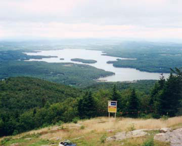
Lake Sunapee from near the summit of Mount Sunapee. Photo by Destiny Saxon.
We have been undertaking 1:24,000-scale geological mapping of the area surrounding Lake Sunapee, New Hampshire. Several important features of the Acadian orogen in NH come together in this area, including plutons associated with all four groups of the NH Plutonic Series, as well as a narrow septum of metasedimentary rocks related to larger structures of the orogen.
Our work in the area was an attempt to help address questions about the relationships between the Mount Clough and Cardigan Plutons, their role in nappe-stage and subsequent deformation, and the significance of plutons of the Spaulding and Concord Groups in the overall structure of the Acadian orogen. We found that the Cardigan and Mount Clough Plutons may indeed grade into one another, but that ductile structures have "sandwiched" the Sunapee Septum in between the two, obscuring their original relationship. The structure of the septum appears to have been exploited by late syn-tectonic Spaulding Group magmas, and the later post-tectonic Concord Group magmas seemed to follow some of the same conduits.
But perhaps most importantly, we discovered that previously un-recognized brittle faulting dominates the geology of the area -- Lake Sunapee is a graben! We suspect that fluid circulation along these faults may ultimately have been responsible for the high levels of Uranium found in the rocks of the area. This is of concern because there have been several reports of domestic water wells in the area having high levels of Radon, or high levels of Uranium itself, with noted adverse impacts on the health of residents drinking these waters.
Our continued mapping will necessarily include study of joint and fracture systems, as they are important to addressing some of the structural problems raised above; they also control groundwater flow in the bedrock aquifer. In particular, the bedrock aquifer of the Lake Sunapee watershed is likely important in the hydrology of the lake, the State's largest high-altitude lake.
Finally, there is much interest in the geology of this area among the lay public. The area's natural beauty attracts many tourists and summer (as well as year-round) residents, many of whom are particularly interested in natural history. The project area includes Mount Sunapee State Park, and the Monadnock-Sunapee Greenway Trail, as well as the John Hay National Wildlife Refuge.
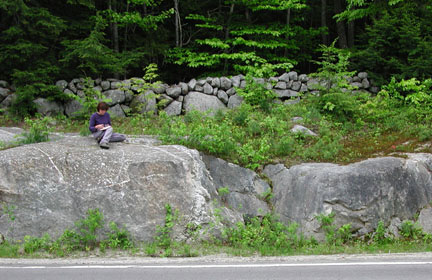
Christina Burt in the field, June 2001.
The mapping entails bushwhacking through remote forests, climbing steep mountains, and spending long hours in the hot sun carefully studying confusing rock outcrops. Successful students are motivated self-starters able to work independently with minimal supervision, who have taken courses in Structural Geology and Petrology prior to the field season.
This work has been supported by the USGS EDMAP program, part of the National Cooperative Geologic Mapping program, with matching funds from Keene State College. Students have also received funding for geochemical and isotopic analyses of rocks from the map area from the KSC Undergraduate Research Fund. Students involved in the project to date have included: Dina Andretta (recon mapping, Summer 1999); Destiny Saxon (mapping, Summer & Fall 2000; geochemistry Fall 2000); Christina Burt (geochemistry, Fall 2000; mapping, Summer & Fall 2001); and Josh King (geochemistry, Fall 2000).
Supported by the  and
and  Thanks!
Related Documents
- Allen, T., 2003, Bedrock Geology of the Lake Sunapee Area, West-Central New Hampshire, in Brady, J.B., and Cheney, J.T., eds., Guidebook to Field Trips in the Five College Region, New England Intercollegiate Geological Conference, 95th Annual Meeting. pp. A4.1-A4.14.
Manuscript
- Burt*, C., Saxon*, D., and Allen, T.T., 2002, Bedrock Geology of the Lake Sunapee Area, New Hampshire, Geological Society of America Abstracts with Programs, 34(1):A-68
Posters
- USGS EDMAP 2001 Proposal Narrative
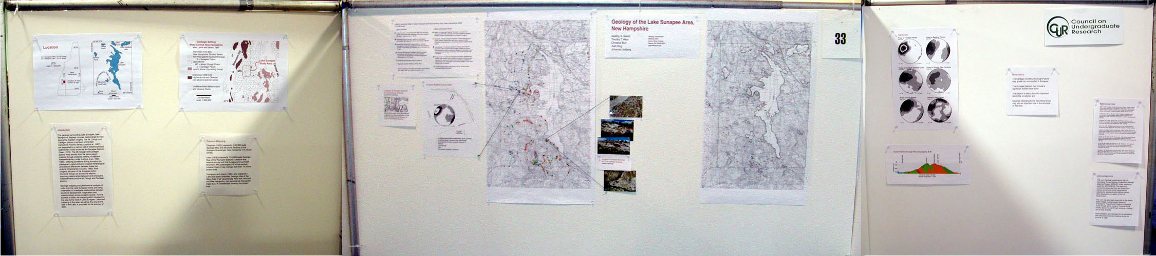
- Saxon*, D., Allen, T. T., Burt*, C., King*, J., and Lindberg*, J., 2001, Geology of the Lake Sunapee Area, New Hampshire, Geological Society of America Abstracts with Programs, 33(1):A-12
Posters
- USGS EDMAP 2000 Proposal Narrative
- Allen, T., 1997, Nappes, Gneiss Domes, and Plutonic Sheets of West-Central New Hampshire. Timothy W. Grover, Helen N. Mango, and Edward J. Hasenohr, editors, Guidebook to Field Trips in Vermont and Adjacent New Hampshire and New York, New England Intercollegiate Geological Conference, 89th Annual Meeting. pp. A2.1 - A2.19.
HTML Web Page
Manuscript
Earlier Work on the Geology of Western New Hampshire
- Allen, T. and C. P. Chamberlain 1989. Thermal consequences of mantled gneiss dome emplacement. Earth and Planetary Science Letters 9(3): 392-404.
- Allen, T. and C. P. Chamberlain 1988. Thermal Consequences of Gneiss Dome Formation. EOS, Transactions of the American Geophysical Unions 69(16): 509.
Abstract
- Chamberlain, C. P., J. B. Thompson and T. Allen 1988. Stratigraphic and Structural Relationships of the Fall Mountain Nappe. Bothner, W. A., editor, Guidebook for Field Trips in Southwestern New Hampshire, Southeastern Vermont and North-Central Massachusetts. New England Intercollegiate Geological Conference, 80th Annual Meeting, pp. 32-39.
- Allen, T. 1985. A reinterpretation of the Fall Mountain Nappe, as seen from Fall Mountain, North Walpole, New Hampshire, abstract. Geological Society of America Abstracts with Program 17(1): 2.
Web Links
- Sunapee-Ragged-Kearsarge Greenway Coalition
- Monadnock-Sunapee Greenway Trail Club
- Mount Sunapee State Park
- Mount Sunapee Resort
- Lake Sunapee Cruises
- Lake Sunapee Protective Association
- The Fells and John Hay National Wildlife Refuge
This website and all documents presented here were written by Timothy T. Allen in his private capacity. No official support or endorsement by the University System of New Hampshire or Keene State College is intended or should be inferred. Copyright © 1992-2011 Timothy T. Allen.
website by ThorpeAllen.net
December 2010