Nappes, Gneiss Domes and Plutonic Sheets
of
West-Central New Hampshire
by
Tim Allen, Geology Dept., MS 2001, Keene State College, Keene, NH 03435-2001,
tallen@keene.edu
Originally published in: Timothy W. Grover, Helen N. Mango, and Edward J. Hasenohr, editors, Guidebook to Field Trips in Vermont and Adjacent New Hampshire and New York, New England Intercollegiate Geologic Conference, 89th Annual Meeting. pp. A2.1 - A2.19.
This document is also available as an Adobe Acrobat PDF file ![]() .
.
Introduction
The area between Keene and Hanover in west-central New Hampshire (NH; Figure 1) is home to some "classic" geology of the Acadian Appalachians. This geology includes (1) fold nappes which transported highly metamorphosed deep-basin sediments over less-metamorphosed shelf sediments, (2) gneiss domes which subsequently deformed (and metamorphosed) these nappes, and (3) large anatectic plutonic sheets, whose emplacement may have been intimately involved with the formation of the nappes. These rocks are encompassed within the Central Maine Terrane (CMT; Eusden & Lyons, 1993), and astride the Bronson Hill Anticlinorium (BHA; Billings, 1956). On this trip, we are primarily interested in the relationships between and among rocks on the BHA and those further east in central NH. The relationship of these rocks (NH sequence) with those to the west (Vermont sequence) is the subject of other trips at this conference (A6, Armstrong et al, 1997.; and C1, Thompson et al., 1997).
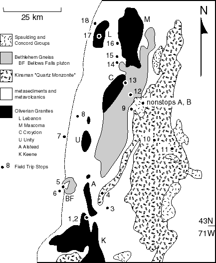
Figure 1: Schematic geologic map of west-central New Hampshire, showing approximate locations of field trip stops
Metasedimentary and Metavolcanic Stratigraphy
An important part of understanding the geology in any region is the ability to recognize the relative sequence in which the rock units were deposited or intruded, from principles of super-position and cross-cutting relationships, but also from fossil assemblages and radiometric dates. On the basis of fossils discovered in the Littleton area, Billings and others (1934, 1935, 1937) were able to define a stratigraphic sequence for the metavolcanic and metasedimentary rocks of the BHA (Figure 2). Once a sequence is established, mapping in adjacent areas can commence by making correlations back to the known rocks. Billings, his students and others proceeded to map much of the rest of NH, with reference to the Littleton section, leading to the publication of a NH state geologic map in 1956. Most of the rocks throughout NH (with a few notable exceptions) are, however, devoid of the fossils needed to corroborate one's position in the stratigraphic sequence, thus correlations must be made primarily on the basis of lithologic characteristics. Given a high degree of structural complexity, a wide range of metamorphic changes and degrees of weathering, large expanses of intervening plutonic rocks, and significant original sedimentological variations, such correlations (upon which structural and tectonic interpretations hinge) are often problematic.
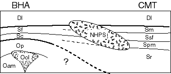
Figure 2: stratigraphy and rock descriptions (see table below) for the field trip area
- Bronson Hill Anticlinorium
- Dl: Devonian Littleton formation,
- an aluminous marine turbidite (good graded bedding) with quartzites and minor volcanics. This rock is regarded as a flysch deposit preceding the Acadian orogeny, and was derived from a source terrane to the east.
- Sf: Silurian Fitch formation,
- a shelf-type dirty limestone or limey mudstone
- Sc: Silurian Clough formation,
- a clean quartzite and quartz pebble conglomerate, with minor amounts of dirty limestone and greywacke or aluminous shales; locally bearing fossils (Boucot and Thompson, 1958, 1963). The Silurian rocks unconformably overlie the Ordovician rocks, including the Oliverian Granites.
- Ool: Oliverian Gneiss,
- foliated calc-alkaline granites, tonalites and trondjhemites with ages of approximately 442-456 Ma (Naylor, 1969; Zartman & Leo, 1985; Aleinikoff c.f. Lyons et al., 1996).
- Op: Ordovician Partridge formation,
- a carbonaceous and sulfidic black shale, with significant volcanogenic material (abundant coticules). The upper volcanics are probably coeval with the Oliverian granites.
- Oam: Ordovician Ammonoosuc Volcanics,
- bimodal volcanics including basalt and rhyolite flows, tuffs, and pyroclastics. At ~468 Ma old (Aleinikoff c.f. Moench et al., 1995) they have been intruded by the Oliverian granites.
- New Hampshire Plutonic Series
- Dcg: Concord Granite,
- a two-mica granite: 354 +/-5 Ma (Harrison et al., 1987)
- Dsg: Spaulding Group,
- diorite to granite in composition: 392 Ma (Lyons & Livingston, 1977)
- Dbg: Bethlehem Gneiss,
- foliated granite to tonalite, 407 +/-5 to 410 +/-5 Ma (Moench et al., 1995)
- Dkqm: Kinsman Quartz Monzonite,
- tonalite to granite, 413 +/-5 Ma (Barriero & Aleinikoff, 1985)
- CMT metasediments
- Dl: Devonian Littleton formation,
- as described above
- Sm: Silurian Madrid formation,
- a dirty "ribbon" limestone, with occasional black shales, sulfide rich zones, and arenaceous (sandy) rocks containing calcareous concretions.
- Ssf: Silurian Smalls Falls formation,
- includes quartzites, argillites (shales), and limestones, generally black in color, with abundant pyrrhotite and pyrite.
- Spm: Silurian Perry Mountain formation,
- typically impure but well bedded sandstones, sometimes with thinly interbedded (cyclic) shales (rarely showing graded beds). Non-calcareous and usually non-sulfidic.
- Sr: Silurian Rangeley formation,
- includes all kinds of rocks including graphitic and sulfidic black shales, polymict conglomerates (matrix dominant), and arenaceous lenses with calcareous concretions. The Rangeley has been described as an olistostrome (Eusden et al., 1996a, b; Allen, 1996a), and was deposited in a rapidly subsiding basin from a source terrane to the northwest (Moench, 1979).
As the state map was being compiled, Thompson (1954, 1956) discovered structural complications on the BHA, arising from the recognition of distinct stratigraphic units (based on fossil occurrences) in rocks that had previously been mapped as belonging to one formation. This lead to a second round of mapping in the region, still referencing the Littleton section, that culminated in the oft-cited 1968 paper by Thompson and others, establishing the current paradigm outlined above.
Meanwhile, Lyons, his students, and others working in central NH found that the BHA stratigraphy didn't fit very well with rocks exposed there, and developed a new informal lithostratigraphy for their work (c.f. Duke et al., 1988). Billings and others (1941, 1946, 1975) had earlier wrestled with this problem in the Mount Washington-Gorham area further north, and in revisiting this area Hatch and others (1983; Duke et al., 1988) extended to central NH a stratigraphic sequence established in the Rangeley area of Maine (Figure 2; Boone et al., 1970). A key component of this interpretation is the recognition of a change in depositional environments, from a shelf-type on the BHA to a deep closed basin in the CMT. A third generation of mapping was undertaken in western NH to determine the relationship between the stratigraphy of rocks on the BHA and that to the east in central NH (Chamberlain et al., 1988). While the rocks themselves have remained essentially unchanged for several hundred million years, their exposures (too often too few and far between) and our interpretations of them seem to change continuously. The release of a new NH state geologic map is imminent (Lyons et al., 1997), but many interesting problems persist.
Intrusive Igneous Rocks
Billings' state map (1956) also showed several suites of intrusive igneous rocks in this region (Figure 1), including the Oliverian magma series and the New Hampshire Plutonic Series (NHPS), including the so-called Kinsman Quartz Monzonite (KQM), Bethlehem Gneiss, Spaulding Group and Concord Group. At that time, the details of age relationships, the sources of these magmas, and their modes of emplacement were uncertain. Since then, the application of radiometric dating techniques, petrologic and isotopic studies, geophysical and structural investigations, and thermal modelling have vastly improved our understanding of the Oliverian and NHPS rocks.
The Oliverian suite is comprised of granites, tonalites and trondjhemites ranging in age from 442-456 Ma (Naylor, 1969; Zartman & Leo, 1985; Aleinikoff c.f. Lyons et al., 1996) which form the core rocks of the en echelon mantled gneiss domes making up the BHA, as well as a few discordant intrusions just off the axis of the BHA to the west. These rocks have an internal gneissic foliation paralleling their contacts with wall rocks, giving rise to their (sometimes asymmetric) domal structures. Structures within the mantling strata, including Silurian and Devonian rocks substantially younger than the core gneisses, also exhibit this doming. In addition, metamorphic isograds in these strata commonly wrap around the domes, with the grade of metamorphism increases toward the center of the dome. It is thought that the domes might have been created by diapiric rise (Thompson et al., 1968), resulting from a density inversion between the core materials and the mantling strata (Fletcher, 1972), during the early Devonian Acadian orogeny. Such a model has been demonstrated by scaled gravity tectonic experiments (Ramberg, 1973). Lyons and others (1996) used gravity measurements to confirm the geometry of these domes, and their mushroom- shaped models support reactivated diapiric rise of the core rocks. The metamorphic patterns might be the result of focussed heat flow due to contrasts in thermal conductivity (Allen & Chamberlain, 1989). The cores of the domes may also represent relict volcanic islands of an oceanic island arc (Hitchcock, 1883, 1890 c.f. Thompson et al., 1968) -- an interpretation which is not incompatible with diapiric rise. One school of thought suggests that the docking of the Bronson Hill island arc with the Laurentian continent was responsible for the Taconic orogeny.
The NHPS were emplaced during and after the early Devonian Acadian orogeny. Of these, the Mount Clough pluton and the Cardigan pluton are the most voluminous. Both of these plutons are heterogeneous granitoids, ranging from granite (sensu stricto) to quartz diorite but being predominately granodiorite. Although compositionally very similar (Billings & Wilson, 1964), the rocks of the these plutons do differ in texture and mineralogy and have been identified as separate units, the Mount Clough pluton being comprised of Bethlehem Gneiss, and the Cardigan pluton of KQM (although no longer considered a quartz monzonite).
Characteristic of the KQM are abundant potassium feldspar megacrysts in a course groundmass of quartz, plagioclase, biotite, muscovite and garnet. In some places, garnet becomes the dominant mineral suggesting zones of restite entrained within the magma. The Bethlehem Gneiss is a more homogeneous micaceous granodiorite distinguished from the KQM by a prominent gneissic foliation and the lack of potassium feldspar megacrysts and restites.
Lathrop and others (1994, 1996) made detailed Sr, Nd and O isotopic studies of the Mount Clough and Cardigan plutons to address questions about the nature of origin and source for these rocks. Their results show that, while isotopically heterogeneous and complex, the Bethlehem Gneiss and KQM magmas formed from anatectic melting of the adjacent metasedimentary rocks found in the BHA and the CMT, with very little if any contribution from the mantle. The original sedimentary material in the CMT was enriched in heat producing elements, which when the crust was thickened during the Acadian orogeny, would have provided a sufficient heat source for melting in situ (Chamberlain & Sonder, 1990). However, the rocks of the BHA are not so enriched, and so would have required an external heat source or deeper burial for melting.
In addition to the Mount Clough and the Cardigan plutons, several smaller satellite plutons of Bethlehem Gneiss (or KQM) have also been mapped, for example the Bellows Falls pluton. Geophysical investigations, combined with geologic structural constraints, indicate that these plutons are floored by metasedimentary rocks and were probably emplaced as large sill-like bodies, not much thicker than about 2000 meters (Nielson et al., 1976; Kruger & Linehan, 1941). It is thought that several of these plutons may have at one time been connected, covering the entire area; the Bellows Falls Pluton perhaps being an outlier of the Mount Clough Pluton, for example.
It should further be noted that the Bethlehem Gneiss and the KQM cannot be distinguished from one another on the basis of Nd, Sr, or O isotope compositions (Lathrop et al., 1996), nor their major element compositions (Billings & Wilson, 1964). Thus it has been suggested that these two magmas were originated from the same parent material, with their mineralogical differences the result of different metamorphic conditions during their crystallization, or perhaps post- crystallization metamorphism (Chamberlain & Lyons, 1983). Differences in texture could be related to the degree to which the plutons were involved in nappe-stage deformation, the Mount Clough pluton of Bethlehem Gneiss being the further west on the eastern flanks of the BHA, while the Cardigan pluton is within the CMT. Allen proposed (1984, 1985) that the upper-most Fall Mountain nappe may have been aided in its transport to the west by the intrusion of Bethlehem Gneiss as a sheet along its sole, such that the Fall Mountain outlier and the Bellows Falls pluton are a package. To the east, the Huntley Mountain Spur of the Cardigan pluton is mapped along the sole of the Fall Mountain nappe (Chamberlain et al., 1988).
The Spaulding Group rocks, also syn-orogenic, and the post-orogenic Concord Group, may be associated with migmatite zones (Allen & Chamberlain, 1992; Allen, 1994, 1996a, b) found extensively along the axis of the Central NH Anticlinorium (Eusden et al., 1987; Eusden & Lyons, 1993). Thermal relaxation following the crustal thickening of the Acadian orogeny could have lead to melting of CMT rocks to produce the post-orogenic Concord Group plutons (Chamberlain & England, 1985).
Structure and Metamorphism
Thompson and others (1968) mapped a series of several west-vergent isoclinal fold nappes lying on and lapping over the BHA. These were recognized on the basis of repeats and inversions of the stratigraphy as well as structural features. The nappes were then deformed and backfolded by the subsequent diapiric-rise of the Oliverian domes (Robinson & Hall, 1979), greatly complicating the structure of the region. Further to the south, thrust faulting was recognized as an intermediate stage between emplacement of the fold nappes and subsequent doming (Thompson et al., 1987). Clearly, not all of the nappes are strictly fold nappes, the upper-most Fall Mountain nappe probably being more of a thrust structure (Allen, 1984, 1985, Chamberlain et al., 1988), with intimate involvement of rocks from the NHPS, as discussed above. On the eastern flanks of the CMT, to the east of the Central NH Anticlinorium, a somewhat similar set of early nappes are recognized, there being east-vergent (Eusden et al., 1987). The Central NH Anticlinorium is interpreted as a "dorsal zone" or "pop-up" structure forming the core of the Acadian orogeny (Eusden et al., 1987; Eusden & Lyons, 1993).
The succession of nappes emplaced over the BHA explained the inversion of metamorphic isograds observed in the region (Chapman, 1953). Each nappe, rooted to the east of the BHA in the CMT, brought deeper, hotter rocks westward with it, over colder previous nappes and autochthonous rocks. Thus rocks of high metamorphic grade were correlated to high tectonic level, in this case later nappes (Thompson et al., 1968). Spear and others (1990, 1992; Kohn et al., 1992) have correlated this scenario with pressure-temperature-time (P-T-t) histories of metamorphism found in rocks from the various nappes, wherein the nappe or thrust emplacement of hot rocks drives metamorphism of underlying colder rocks as the nappe cools. Indeed, they have gone on to postulate the existence of additional nappes (or thrust sheets), that are not exposed anywhere, on the basis of P-T-t histories. Certainly, within the CMT east of the BHA, the metamorphic pattern shows localized regions of high- or low-grade metamorphism (Chamberlain & Lyons, 1983). Chamberlain (1986) has explained these as the result of metamorphism enhanced by sequential episodes of intersecting folds.
Conclusion
The geology seen here in west-central NH appears to be characteristic of many orogenic belts. Thompson and others (1968) drew analogies between their interpretation of nappes and gneiss domes with similar structures observed in the western Alps, as further developed by Thompson and others (1990, 1993). Mantled gneiss domes are present in many deeply eroded mountain belts, including the Alps, Caledonides, Canadian Cordillera and the Appalachians (Eskola, 1949; Allen & Chamberlain, 1989), as well as the Himalaya and Karakorum (Allen & Chamberlain, 1991; Searle et al., 1989; Kundig, 1989). Perhaps their previous experience in west-central NH influenced their thinking, but Allen & Chamberlain (1991) recognized in the Karakorum of Pakistan a very similar scenario to that outlined here: fold-and-thrust nappes inverting the crust and thus metamorphic isograds, with subsequent deformation by gneiss domes of re-mobilized earlier granitic intrusives (Allen, Smith, Zeitler & Chamberlain, unpublished data).
Acknowledgements
I would like to express my sincere appreciation to C. Page Chamberlain, James B. Thompson, Jr., and John B. Lyons for first showing me these outcrops, and introducing me to and involving me in the study of the geology of my home stomping grounds. Any errors or omissions are mine alone. I'm sure that I have overlooked some important references, and haven't adequately represented all of those cited.
Road Log
We will depart at 8:00 AM from the intersection of Routes 12 and 12A (Maple Avenue) in northwest Keene, NH. Please carpool, bring a lunch, and have a full tank of gas -- enough for at least 150 miles of driving. The best reference map I can suggest would be a NH state highway map -- we're going to cover a lot of ground!
Mileage
0.0 Set trip meter to zero at the Rt. 12 overpass over Rt. 12A.
0.7 Stoplight, continue on Rt. 12A towards Surry.
4.6 roadside outcrops of Oliverian granite in the Keene Dome, view of Surry Mountain (see stops 1 & 2 below)
to the east.
7.0 Park on the right side, as far over as possible. Leave hazard indicators flashing.
STOP 1: Border Gneiss of the Keene Dome (10 minutes) The Oliverian rocks of the Keene Dome are non-peraluminous granodiorite to quartz monzonite, here strongly laminated in the border region of the dome, adjacent to Surry Mountain -- a septum of metasediments between the Keene and Alstead domes, in a vertical syncline that folds the axial plane of the nappes. Within the border gneiss, one finds thin mafic layers and quartz "eyes." Return to the vehicles and continue north on 12A.
7.2 Turn right onto River or Gilsum road
7.4 Park on the right side, as far over as possible. Leave hazard indicators flashing.
STOP 2: Surry Mountain Septum (10 minutes) Exposed here are some of the metavolcanic and metasedimentary rocks of the Surry Mountain septum (see stop 1 above). We may find gedrite- cordierite assemblages in a "garbenschiefer" texture (better exposed up on Surry Mountain); the rock is also reported to contain Na-micas with talc intergrowths (J. B. Thompson, Jr., pers. comm., 1992). Return to the vehicles and continue east.
11.4 Stop sign across stone arch bridge, turn left onto Rt. 10 north through Gilsum
15.0 Park on the right side, as far over as possible. Leave hazard indicators flashing. Take care in crossing the
highway.
STOP 3: High-Grade Rangeley Formation (15 minutes) This is Stop 9 of Chamberlain and others (1988) and Stop 10 of Spear (1992). The metamorphic mineral assemblage is garnet + cordierite + biotite + K-feldspar + sillimanite + plagioclase, and represents a localized metamorphic "hot spot." Chamberlain and others (1988) mapped these rocks as part of the root zone for the Fall Mountain nappe, and Chamberlain (1986) interpreted the high grade of metamorphism to be the result of metamorphism enhanced by sequential episodes of intersecting folds (e.g. syncline + syncline). Spear (1992) mapped these rocks as the upper plate of the Chesham Pond nappe, and interprets the P-T-t path as cooling following thrust emplacement and backsliding. Return to the vehicles and continue north on 10.
18.6 Turn left onto Rt. 123 west at Marlow
19.9 Park on the right side, as far over as possible. Leave hazard indicators flashing.
STOP 4: Huntley Mountain Spur (10 minutes) This is a spur of KQM extending southwest from the Cardigan pluton, mapped as representing the sole of the Fall Mountain nappe (Chamberlain et al., 1988). The rocks are highly foliated. Continue west on 123.
23.1 Flashing yellow light, East Alstead. Continue straight through on 123 west
24.3 Mill Hollow. Continue through on 123 west
27.2 Rt. 12A comes in from the left, continue on 123 west
28.0 Rt. 123A comes in from the right, continue on 123 & 12A through Alstead village
28.6 Rts. 12A and 123 diverge, turn left staying on 123 west
30.6 Stop sign, Rt. 123 turns left, continue straight across onto Cold River Road
31.2 (optional stop) outcrops in the river are of a window to the floor of the Bellows Falls pluton
31.9 outcrop on far bank of the river are of the Bellows Falls pluton
32.5 another river outcrop of the floor under the Bellows Falls pluton, Fall Mountain looms to the right.
33.3 Stop sign, intersection with Rt. 123, bear right on 123 west
33.5 Stop sign, intersection with Rt. 12, turn right onto 12 north
34.5 Stop lights, continue through to just past the railroad yard
34.6 Park on the right side, as far over as possible. Leave hazard indicators flashing. Take care in crossing the
highway and scrambling down to the outcrops in the river.
STOP 5: Fall Mountain Nappe and Bellows Falls Pluton (20 minutes) This is Stop 1 of Chamberlain and others (1988) and Stop 5 of Spear (1992). Gray schists of the Rangeley Formation from the CMT, containing characteristic calc-silicate and amphibolite "pods," is here in contact with the Bethlehem Gneiss of the Bellows Falls pluton. Note the sillimanite pseudomorphs after andalusite ("turkey tracks") in the schist, and garnets in the Bethlehem Gneiss associated with assimilated blocks of schist. The CMT rocks on Fall Mountain were clearly of higher metamorphic grade than the BHA rocks surrounding and underneath the Bellows Falls pluton, which implies significant horizontal transport from the root zone in Marlow. Much of this transport and shortening may have been taken up within the Bellows Falls pluton (Allen, 1984, 1985; Spear, 1992). The metamorphic evolution of Fall Mountain shows cooling following emplacement of hot rocks over cold (Allen, 1984); Spear (1992) develops a more complex scenario. The hike up Fall Mountain (Mount Kilburn) via the tower access road is interesting (Stop 2 of Chamberlain et al., 1988). Return to the vehicles and continue north on Rt. 12.
35.1 Stop light, turn left and cross the bridge to Vermont
35.3 Stop sign at end of bridge, turn left onto Rt. 5 south
35.6 Downtown Bellows Falls, continue south on 5
35.9 Stoplight, bear right uphill on Rt. 121 west
36.9 Turn left around monument onto Gage St.
37.1 Continue straight ahead onto dirt road
37.3 Park on the right or left sides, as far over as possible.
STOP 6: Littleton Formation in the Saxton's River (20 minutes) This is Stop IV-2 of Zen (1989) and Stop 3 of Spear (1992). No hammering, please. The rocks here are a staurolite schist and quartzite showing spectacular graded bedding (grade reversed due to metamorphism) characteristic of a turbidite deposit. The rocks are isoclinally folded and otherwise deformed, with inverted topping directions and several hinges apparent. Much of the deformation may well have occurred during deposition, when these rocks were still soft sediment. These rocks are part of the Skitchewaug nappe, structurally below the Bellows Falls pluton and the Fall Mountain nappe. P-T paths from other outcrops in this section show heating with loading (Spear, 1992), consistent with the emplacement of the hot Fall Mountain rocks over these colder rocks. After getting your photographs, return to the vehicles and continue along the dirt road.
37.9 Rejoin Rt. 121 headed back into town
38.4 Stoplight at bottom of hill, turn 90 degrees to the left onto Rt. 5 North (to I-91) -- not back through downtown
39.2 Stop sign, continue north on 5
42.0 Rt. 5 turns off to the right, Rt. 103 ahead to the left -- go straight up the on-ramp to I-91 north
46.2 first view of Mount Ascutney, a remnant volcano associated with the White Mountain Magma Series,
straight ahead For more information, see Schneiderman (1988).
48.6 Exit at Springfield
48.9 Stop sign at end of ramp, turn left to go north on Rt. 5 & east on Rt. 11
49.3 Turn left onto Rt. 5 north, just before the toll bridge
50.6 Park in the fork on the right.
STOP 7: Fossiliferous Clough Quartzite of the Skitchewaug Nappe (10 minutes) This is Stop IV-1 of Zen (1989). No hammering, please. These rocks have been highly deformed, and metamorphosed to the staurolite zone, and yet calcareous bands within the quartzite contain recognizable fossils and fossil fragments, including crinoid stems, corals, and brachiopods (Thompson, 1954; Boucot & Thompson, 1963). Similar fossils have been found in several other locations within the Clough Quartzite throughout the region, such that it is a good Silurian marker and very useful in deciphering the stratigraphy and structure of the BHA. Continue north on 5.
54.7 Rt. 143 comes in from the left, continue north on 5
60.3 Yield sign, turn right towards Claremont
61.2 Stoplight at intersection with Rt. 12A, continue straight towards Claremont
63.6 Turn left, following sign for Newport and Sunapee (not downtown)
64.2 Stoplight, continue straight through
64.6 Park in turnout to the right, just before the stoplight at intersection with Rt. 120. This may well be our
Lunch Stop. Take care in crossing the highway to roadcuts at the intersection.
STOP 8: Blue quartz eyes in pyroclastic volcanics (15 minutes) The blue quartz eyes, from the exsolution of very fine rutile crystals within the quartz, are indicative of very high temperatures, but these rocks have only been metamorphosed to biotite zone (low grade). This rock represents a high-temperature volcanic ignimbrite, with lenticles of pumice, lapilli, etc...; probably equivalent to the Post Pond Volcanics in Vermont. The coarse pyroclastic sequence is best visible on a water polished surface (cross back to the riverside park). A slaty cleavage has been superposed, creating a lineation in the rock. Look down-dip to see these features. (J. B. Thompson, Jr., pers.comm., 1992) Return to vehicles and continue towards Washington Street.
64.8 Stoplight, turn left onto Rts. 11 & 103 east (Washington Street, Claremont). Continue through all the
stoplights along this strip.
71.7 outcrops of Bethlehem Gneiss
73.7 Stoplight, go straight
74.1 Stoplight at intersection with Rt. 10 (Main Street, Newport), turn left to follow Rts. 11 & 103 east
74.2 Turn right following sign for Rts. 11 & 103 east
74.4 Yield sign, continue onto Rts. 11 & 103 east
77.3 Rts. 11 & 103 diverge (Guild), bear right to stay on Rt. 11 east toward Sunapee
79.7 Rt. 103B on the right, continue straight
79.8 Flashing yellow for Sunapee Harbor, continue straight
80.0 Turn left onto Sargent Road, park on dirt track by Sunapee Fire Station. Take care in crossing the highway.
STOP 9: Spaulding Quartz Diorite and pegmatite autoliths (15 minutes): The Spaulding, dated at 392 million years, somewhat foliated, cross-cuts the KQM and the Bethlehem Gneiss, thus a late tectonic intrusive. Here it is cut by pink pegmatites (with perthitic feldspar). The pegmatite and the Spaulding are magmatically related, and here you can see "autoliths" of the pegmatite within the Spaulding and vice-versa. At the north end of the outcrop are true xenoliths (as opposed to autoliths) of the country rock, including the KQM. In some places the KQM has become disaggregated, with incorporation of feldspar xenocrysts into the Spaulding. This represents an igneous breccia, with flow foliation, resulting from explosion venting of fluidized magma. (J. B. Lyons, pers.. comm., 1988). Return to the vehicles and enter Rt. 11 heading west from the fire station.
80.3 Flashing yellow for Sunapee Harbor, continue straight
80.4 Turn left onto Rt. 103B south
81.0 small quarry operation, with antique steam tractor on left
82.8 View of Mount Sunapee Ski Area ahead through trees.
The ridge extending south-southwest from Mount Sunapee to Lempster Mountain, and north from Sunapee to Mount Cardigan, represents a septum of metasediments (interdigitated with the Huntley Mountain Spur) caught between the Cardigan pluton to the east and the Mount Clough pluton to the west. Mapped by Dean (1976) based on the BHA stratigraphy, a new look at these rocks with insights from the CMT and other areas, may help tie together the stratigraphy and structure of southwestern NH with that to the north and west, as well as furthering our understanding of the relationships between the Cardigan and Mount Clough plutons.
83.8 Stop sign, proceed across and around the Mount Sunapee Traffic Circle, leaving on Rt. 103 east.
84.7 outcrops of KQM injected with multiple dikes of aplite
85.1 outcrops of KQM with rafts of metasediment
86.2 Newbury Harbor
86.3 Intersection with Rt. 103A
Alternate Route (shortcut, skipping stops 10 and 11):
86.3 Turn left onto R.t 103A north
88.7 Pull off on the LEFT side of the road to park just before Ramblewood Circle. Leave hazard indicators
flashing, and take care in crossing the highway. Across the road is an interesting outcrop of the KQM.
89.2 Rt. 103A bears to the left, continue following it to the north.
91.3 Turn right onto King Hill Road, towards I-89 southbound
92.3 Bog Road takes off the left, continue on King Hill Road
92.5 The author's childhood home is on the left
93.0 View of Mount Kearsarge ahead (see comments at mile 99.0).
93.7 Under the highway, turn left on to entrance ramp for I-89 northbound. Pick up the road log at mile 109.7,
and subtract about 16 miles from subsequent mileage readings.
Original Route (the long way):
86.3 Rt. 103A goes off to the left, continue east on Rt. 103
86.8 more outcrops of KQM
87.1 Mountain Road on the right, continue on 103 east. K-Ar dating of kaolinite gouge from the Newbury Fault
zone exposed here yielded an age of 160 Ma (J. B. Lyons, pers. comm., 1988)
89.1 Flashing yellow, South Newbury
91.4 Park on right side of road, as far over as possible. Leave hazard indicators flashing. Take care in crossing the
highway.
STOP 10: Restites in the Kinsman Quartz Monzonite (15 minutes) This is Stop 10 of Lyons (1988) and Stop IV-5 of Zen (1989) Garnetite (garnet-cordierite-biotite-plagiogclase-quartz) pods and layers within the KQM represent restites of xenoliths of Littleton schist undergoing anatexis, anatectic melting of CMT and BHA metasediments being the source of the magma making up the pluton (Lathrop et al., 1994, 1996). The KQM is here a granodiorite with the characteristic K- feldspar megacrysts and a mineral assemblage including sillimanite (fibrolite) as well as garnet and cordierite The Cardigan pluton is at its maximum preserved thickness of 2.5 km here, based on gravity studies (Nielson et al., 1976; Lyons, 1988). The Cardigan pluton to the south of here was briefly considered as a potential host for the disposal of high-level radioactive wastes (Department of Energy, 1986, p. 3-435). Return to the vehicles and continue east on 103.
91.7 Stoplight at intersection with Main Street, Bradford. Continue straight on Rt. 103 east
92.4 Stoplight at intersection with Rt. 114, continue straight on Rt. 103 east to Warner
98.7 Park on right just before onramp to I-89 south, as far over as possible. Leave hazard indicators flashing.
Take care in crossing the highway.
STOP 11: Kinsman Quartz Monzonite with garnets (15 minutes) This is Stop IV-6 of Zen (1989). Here were are near the eastern edge of the Cardigan pluton, in a garnetiferous phase of KQM, with garnet rimmed or replaced by biotite, and K-feldspar megacrysts partly sericitized and mantled by myrmekite. The Cardigan pluton does not appear to have been initially homogeneous melt (Clark & Lyons, 1986; Lathrop et al., 1994, 1996). The occurrence of garnet within the pluton has been interpreted as both metamorphic (Chamberlain & Lyons, 1983) and igneous (Clark & Lyons, 1986), with evidence now favoring igneous garnet (Lyons, 1988). Return to vehicles and continue east on 103 under the interstate.
99.0 Turn left on to ramp for I-89 north, and take in the view of Mount Kearsarge
Mount Kearsarge (Lyons, 1988), Mount Monadnock to the south (P. J. Thompson, 1988) and Mount Washington to the north (Eusden et al., 1996a, b), are all composed of highly erosion- resistant members of the Littleton formation, noted on each summit for the occurrence of "turkey track" sillimanite pseudomorphs after andalusite and dramatic cyclic graded bedding of quartzites and schists. These peaks essentially mark the trace of the Kearsarge-Central Maine synclinorium.
105.9 View of Mount Kearsarge over right shoulder (exit 10, continue N on I-89)
109.7 outcrop of abundant pegmatite (exit 11, continue N on I-89)
111.0 Slow down and look out the vehicle to the left.
NONSTOP A: "Mount Radon," New London Over the years since the interstate was built, weathering had destabilized the high roadcuts ahead, at NONSTOP B. Several years ago, the NH Department of Transportation undertook a blasting program to re-stabilize this roadcut. It was discovered after the roadcut was first opened that the rock was highly radioactive, as the joint surfaces were covered with ore-grade Uranium deposits. Most of this "ore" had been used as fill for the roadbed. During the re-stabilization effort, great care was taken to keep the dust down and the material removed from the cut was landfilled here in the median strip. This location was chosen in part because it was hoped that any Uranium leached from the rock would be trapped in the highly-reducing environment of the organic sediments of the Messer Pond - Clark Pond bog system down gradient (off to the right; we pass over "Bog Road" ahead). However, much of the Uranium had already been leached from these rocks due to the lowering of the water table resulting from the initial road cut (Dick Lane & Gene Boudette, oral comm., 1995). The author's childhood home is about 3/4 of a mile through the woods to the left!
111.3 overpass over Bog Road
113.0 Slow down and look out the vehicle to the right.
NONSTOP B: Sunapee pluton, New London Note that when the roadcuts were re-stabilized several years ago, the entire height of the cut was blasted in a single lift, for which special permission was needed from the Federal Highway Administration (Dick Lane & Gene Boudette, oral comm., 1995). The rocks are two-mica granite of the Concord Group. This outcrop is famous for the heavy coating of joint faces with Uranium phosphate minerals. This mineralization is presumably represents late hydro-thermal mobilization, and is focussed on fractured zones -- it has now largely been weathered away. Zircons from this rock show little evidence of inheritance, but Uranium loss, with an age of crystallization of 354 +/-5 Ma (Harrison et al., 1987), about the right timing to be the result of anatectic melting following thermal relaxation after tectonic loading (Chamberlain & England, 1985). The pluton intrudes both the Mount Clough pluton and the Cardigan pluton, cutting off the Sunapee Septum of metasediments. As a young boy, the author used to accompany his father who would practice rock-climbing on these roadcuts before the Interstate was officially opened.
114.3 outcrop of Bethlehem Gneiss
115.6 Take Exit 12A for Georges Mills
115.8 Stop sign at end of ramp, turn left under highway
116.0 Turn right onto Stoney Brook Road
116.5 Park on left, just under the highway.
STOP 12: Bethlehem Gneiss of the Mount Clough pluton (10 minutes): A syn-kinematic intrusion inside the Skitchewaug Nappe, and/or below the Fall Mountain Nappe. Granite to tonalite in composition, although highly variable. The rock has a foliation that may be due to flow, and may also be related to its interactions with the nappes. Continue northwest on Stoney Brook Road.
118.3 View ahead of the white ledges over Grantham
These ledges, well-viewed from the interstate, are outcrops of the Clough Quartzite in the mantle of the Croydon dome. Samples from these outcrops contain well preserved brachiopod and other fossils (J.B. Thompson, Jr., pers. comm., 1984). Contained within the boundaries of the private Blue Mountain hunting reserve, they are now essentially inaccessible.
120.9 Stop sign, bear to the left on the Grantham-Springfield Road
122.0 Stop sign, turn right onto Rt. 10 north
122.6 Pass under I-89, continue straight ahead on Old Route Ten
122.9 View to the left of the gray ledges, opposite the entrance to the Eastman development
125.1 Turn left onto Miller Pond Road, under the highway
125.2 Park just past the underpass in class VI road.
STOP 13: Mantle of the Croydon Dome (10 minutes) The rocks here are Ammonoosuc Volcanics exposed at the north end of the Croydon dome, rich in sulfur (pyrrhotite, sphalerite has been found within the Blue Mountain preserve). The core rocks of the Croydon dome, exposed in interstate road cuts a few hundred feet to the south are a true trondhjemite -- a high-sodium granitoid, completely lacking in K-feldspar -- whatever K there is is tied up in biotite and/or hornblende (J.B. Lyons, pers. comm., 1988). Backtrack to Old Route Ten.
125.3 Turn left to continue north on Old Route Ten
127.7 Turn right and pass under highway
127.9 Turn left up on ramp to I-89 north
128.1 outcrops on the right of Bethlehem Gneiss
128.4 outcrops on the right of Bethlehem Gneiss
128.7 outcrop on the right of the core of the Skitchewaug Nappe
130.0 Exit off I-89 at Montcalm
130.2 Stop sign at end of ramp, turn left under highway
130.3 T-intersection, turn left (now heading south)
131.4 Park in turnaround at dead end by the Humane Society
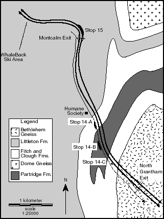
Figure 3: Geology of the Skitchewaug Nappe between North Grantham and Montcalm, after J. B.
Thompson, Jr. (1988), showing the locations of Stops 14 and 15 of this field trip.
STOP 14: Skitchewaug Nappe (30 minutes). This is Stop 1 of J.B. Thompson, Jr. (1988), and your are referred to that source for detailed information about these rocks. We'll make a traverse along the bike path, looking at outcrops of the BHA stratigraphic sequence (Figure 3). The outcrops of Bethlehem Gneiss where we got onto I-89 at Exit 14 are an outlier of the Mount Clough pluton, separated by the Grantham Fault. It appears to be folded into the core of the Skitchewaug Nappe. With a sharp eye, fossils can be observed in the glacially polished surface at the top of northernmost outcrop of the Clough (Stop 14-A in Figure 3). No hammering please! Return to the vehicles and head back the way we came.
132.6 Turn right to pass under the highway
132.7 Turn left on to the ramp to I-89 north, park on right side (as far over as possible) before merging with
highway. Leave hazard indicators flashing.
STOP 15: Littleton Formation (10 minutes) This is Stop 2 of J. B. Thompson, Jr. (1988). A thick section of Littleton schist (Figure 3), rich with staurolite crystals -- some with cruciform twins -- giving the rock a lumpy appearance. Few of the crystals are very fresh, most showing incipient alteration. Bedding is obscure, although the rock has good foliation and a dome-stage mineral lineation. Continue onto I-89 northbound.
136.0 If planning to visit optional stop 16, exit off I-89 at Rt. 4 east for Enfield, otherwise continue on I-89 northbound.
STOP 16: (optional) Mantling Strata of the Mascoma Dome on Moose Mountain
136.3 Yield sign at end of ramp, bear right onto Rt. 4 east
137.9 Intersection with Rt. 4A, continue straight ahead on 4 east across the Mascoma River
138.9 Turn left onto Rudsboro Road
139.8 Turn around and park in turnout on left
This is Stop 6 of J. B. Thompson, Jr. (1988). We will hike uphill through the woods to fields, across the fields, through a sugarbush and more woods to open ledges along the ridge top. Along the way, we will cross over gray schists of the basal Littleton and calc-silicates of the Fitch. Fossils have been found here in the Clough. The ledges are pink quartzite, and from them we can look out to the east over a steep drop down to the Oliverian granite of the Mascoma dome. Return back down to the vehicles, and return down Rudsboro Road towards Mascoma Lake.
140.7 Stop Sign, turn right onto Rt. 4 west
141.8 Rt. 4A again, continue of Rt. 4 west
143.2 Bear right on to ramp to I-89 northbound; rejoin field trip route and add about 7 miles to subsequent
mileage readings.
Original Route:
138.2 Exit off I-89 for Lebanon & Hanover
138.5 Yield sign at end of ramp, bear right onto Rt. 120 north
138.7 Stoplight, continue straight on 120 north
139.1 Stoplight, continue straight on 120 north
140.0 Park on right side of road, as far off as possible, or just ahead at the tire dealer. If on Rt. 120, leave hazard
indicators flashing and beware of traffic.
STOP 17: Oliverian Granite of the Lebanon Pluton (10 minutes) The Lebanon pluton is a discordant pluton of Oliverian granite in the core with an envelope of granodiorite to tonalite. It is found west off the main axis of the BHA, intruded into Partridge Volcanics. Structural and gravity studies show that it is an inverted cone shape plunging to the north-northwest, deforming the Cornish nappe (Lyons et al., 1996). Gravity anomalies suggest that the pluton must be underlain by a sizable body of subjacent metagabbro -- represented by three small bodies of metagabbro which outcrop along the western margin of the pluton. Metamorphism in the adjacent Partridge Formation has been attributed to contact metamorphism associated with original magma intrusion (Spear et al., 1984); focussed heat flow due to contrasting thermal conductivities (Allen & Chamberlain, 1989); and upward domal transport of deeper, hotter rocks (Lyons et al., 1996; Allen & Chamberlain, 1989). Here, the Lebanon granite includes mafic enclaves and pyrite. Once quarried for building stones, the pyrite lead to rust stains on the resulting blocks, and quarrying was abandoned. Return to the vehicles and continue north on 120.
140.5 Stoplight at top of hill (entrance to DHMC), continue straight on 120 north
141.4 Stoplight (entrance to DHMC and Jesse's), continue straight on 120 north
141.8 Stoplight, bear to the left staying on 120 into Hanover
142.6 Stoplight at the Hanover Food Coop, bear to the right staying on 120 north
143.1 Stoplight, turn left onto Rt. 10 south (East Wheelock St)
143.2 Turn right up Dartmouth driveway
143.4 Dartmouth Observatory
143.5 Park wherever there is a spot. Climb down to outcrops alongside building housing Dartmouth College's
Department of Earth Sciences and the Kresge Physical Science Library.
STOP 18: Metavolcanics in mantle of Lebanon Dome -- a green chlorite-amphibolite, with well-developed foliation, apparently meta-basalt.
End of Trip
To get to Pico from here, go down and around the Dartmouth Green to the head of Main Street. Turn right onto West Wheelock Street and follow this across the Ledyard Bridge to Norwich. Take I-91 south to I-89 north to Route 4 west. It is approximately 45 miles.
References Cited
Allen, T, 1984. The Fall Mountain Outlier, a piece of the Fall Mountain Nappe, North Walpole, New Hampshire. Undergraduate Thesis, Harvard University.
Allen, T, 1985. "A reinterpretation of the Fall Mountain Nappe, as seen from Fall Mountain, North Walpole, New Hampshire, (abstract)." GSA Abstracts with Program 17(1): 2.
Allen, T, 1994. "New Hampshire Migmatites: Oxygen Isotope Fractionation During Partial Melting, and Suggestions of Structurally Enhanced Magma Migration." (abstract), EOS, Transactions of the American Geophysical Union 75(16): 360-361.
Allen, T, 1996a. "A Stratigraphic and Structural Traverse of Mount Moriah, New Hampshire." in Guidebook to Field Trips in Northern New Hampshire and Adjacent Regions of Maine and Vermont, Mark Van Baalen, editor, NEIGC 88: 155-169.
Allen, T, 1996b. "Petrology and Stable Isotope Systematics of Migmatites in Pinkham Notch, New Hampshire." in Guidebook to Field Trips in Northern New Hampshire and Adjacent Regions of Maine and Vermont, Mark Van Baalen, editor, NEIGC 88: 279-298.
Allen, T and CP Chamberlain, 1989. "Thermal consequences of mantled gneiss dome emplacement." Earth and Planetary Science Letters 93: 392-404.
Allen, T and CP Chamberlain, 1991. "Metamorphic evidence for an inverted crustal section, with constraints on the Main Karakorum Thrust, Baltistan, northern Pakistan." Journal of Metamorphic Geology 9: 403-418.
Allen, T and CP Chamberlain, 1992. "Pluton Migration Through Crust Leaves Migmatites Behind." GSA Abstracts with Program 24(7): A338.
Armstrong, TR, GJ Walsh and FS Spear, 1997. "A Transect across the Connecticut Valley Sequence in East- Central Vermont," this volume (NEIGC 89).
Barreiro, B and JN Aleinikoff, 1985. "Sm-Nd and U-Pb isotopic relationships in the Kinsman quartz monzonite, New Hampshire." GSA Abstracts with Program 17: 3.
Billings, MP, 1956. The Geology of New Hampshire, Part II - Bedrock Geology. Concord, State of New Hampshire Planning and Development Commission.
Billings, MP, 1935. Geology of the Littleton and Moosilauke Quads, New Hampshire. Concord, State of New Hampshire Planning and Development Commission.
Billings, MP, 1937. "Regional Metamorphism of the Littleton-Moosilauke area, New Hampshire." GSA Bulletin 48: 463-566.
Billings, MP, 1941. "Structure and metamorphism in the Mount Washington area, New Hampshire." GSA Bulletin 52: 863-936.
Billings, MP, and AB Cleaves, 1934. "Paleontology of the Littleton area, New Hampshire." American Journal of Science 28(5): 412-438.
Billings, MP, CA Chapman, RW Chapman, K Fowler-Billings and FB Loomis, 1946. "Geology of the Mount Washington Quadrangle, New Hampshire." GSA Bulletin 57: 261-273.
Billings, MP and JR Wilson, 1964. Chemical analyses of rocks and rock minerals from New Hampshire, Part XIX, Mineral Resources Survey. Concord, NH Department of Resources and Economic Development.
Billings, MP, and K Fowler-Billings, 1975. The Geology of the Gorham Quadrangle, New Hampshire and Maine. Concord, State of New Hampshire Department of Resources and Economic Development.
Boone, GM, EL Boudette and RH Moench, 1970. "Bedrock geology of the Rangeley Lakes - Dead River basin region, western Maine." Guidebook for Field Trips, NEIGC 62: 1-24.
Boucot, AJ and JB Thompson, Jr, 1958. "Late Lower Silurian fossils from sillimanite zone near Claremont, New Hampshire." Science 128: 362-363.
Boucot, A J and JB Thompson, 1963. "Metamorphosed Silurian brachiopods from New Hampshire." GSA Bulletin 74: 1313-1334.
Chamberlain, CP, 1986. "Evidence for the repeated folding of isotherms during regional metamorphism." Journal of Petrology 27: 63-89.
Chamberlain, CP and JB Lyons, 1983. "Pressure, temperature and metamorphic zonation studies of pelitic schists in the Merrimack Synclinorium, south central New Hampshire." American Mineralogist 68: 530-540.
Chamberlain, CP and PC England, 1985. "The Acadian Thermal History of the Merrimack Synclinorium in New Hampshire." Journal of Geology 93: 593-602.
Chamberlain, CP, JB Thompson, and T Allen, 1988. "Stratigraphic and Structural Relationships of the Fall Mountain Nappe." in: Guidebook for Field Trips in Southwestern New Hampshire, Southeastern Vermont and North-Central Massachusetts, WA Bothner, editor, NEIGC 80: 32-39.
Chamberlain, CP and LJ Sonder, 1990. "Heat producing elements and the thermal and baric patterns of metamorphic belts." Science 250: 763-769.
Chapman, CA, 1953. "Problem of inverted zones of metamorphism in western New Hampshire:." Illinois State Academy of Sciences Transactions 46: 115-123.
Clark, RG and JB Lyons, 1986. "Petrogenesis of the Kinsman intrusive suite peraluminous granitoids of western New Hampshire." Journal of Petrology 27(6): 1365-1393.
Dean, CS, 1976. Stratigraphy and Structure of the Sunapee Septum, southwestern New Hampshire. PhD Thesis, Harvard University, 248 pp.
Department of Energy, 1986. Draft Area Recommendation Report for the Crystalline Repository Project, Volume 1, DOE/CH-15(1).
Duke, EF, GI Duke and JB Lyons, 1988. "Geology of the Peterborough and Concord Quadrangles, New Hampshire." Guidebook for Field Trips in Southwestern New Hampshire, Southeastern Vermont, and North-Central Massachusetts, WA Bothner, editor, NEIGC 80: 335-346.
Eskola, P, 1949. "The problem of Mantled Gneiss Domes." Journal of the Geological Society of London 104: 461-476.
Eusden, JD, WA Bothner and AM Hussey, 1987. "The Kearsarge-Central Maine Synclinorium of southeastern New Hampshire and southwestern Maine: Stratigraphic and structural relations of an inverted section." American Journal of Science 287: 242-264.
Eusden, JD and JB Lyons, 1993. "The sequence of Acadian deformations in central New Hampshire." in The Acadian Orogeny: Recent Studies in New England, Maritime Canada, and the Autocthonous Foreland,DC Roy and JW Skehan, editors. GSA Special Paper 275: 51-65.
Eusden, JD, JM Garesche, AH Johnson, J-M Maconochie, SP Peters, JB O'Brien and BL Widmann, 1996a. "Stratigraphy and ductile structure of the Presidential Range, New Hampshire: Tectonic implications for the acadian orogeny," GSA Bulletin 108(4): 417-436.
Eusden, JD, A de Garmo, P Friedman, JM Garesche, A Gaynor, J Granducci, AH Johnson, J-M Maconochie, SP Peters, JB O'Brien and BL Widmann, 1996b. "Bedrock Geology of the Presidential Range, New Hampshire." in Guidebook to Field Trips in Northern New Hampshire and Adjacent Regions of Maine and Vermont, Mark Van Baalen, editor, NEIGC 88: 59-78.
Fletcher, R, 1972. "Application of a Mathematical Model to the Emplacement of Mantled Gneiss Domes." American Journal of Science 272: 197-216.
Harrison, TM, JN Aleinikoff and W Compston, 1987. "Observations and controls on the occurrence of inherited zircon in Concord-type granitoids, New Hampshire." Geochimica et Cosmochimica Acta 51: 2549-2558.
Hatch, NL, RH Moench and JB Lyons, 1983. "Silurian - Lower Devonian stratigraphy of eastern and south central New Hampshire." American Journal of Science 283: 739-761.
Hitchcock, CH, 1883, "The early history of the North-American continent." Science 2: 293-297.
Hitchcock, CH, 1890. "Significance of oval granitoid areas in the lower Laurentian." GSA Bulletin 1: 557-558.
Kohn, M J, FS Spear, DL Orange, D Rumble, and TM Harrison, 1992. "Pressure, temperature, and structural evolution of west central New Hampshire: Hot thrusts over cold basement." Journal of Petrology 33: 521- 556.
Kruger, FC and D Linehan, 1941. "Seismic studies of floored intrusives in western New Hampshire." GSA Bulletin 52: 633-648.
Kundig, R, 1989. "Domal structures and high grade metamorphism in the Higher Himalayan Crystalline, Zanskar region, north-west Himalaya, India." Journal of Metamorphic Geology 7(1): 43-55.
Lathrop, AS, JD Blum and CP Chamberlain, 1994. "Isotopic evidence for closed-system anatexis at mid-crustal levels: An example from the Acadian Appalachians of New England." Journal of Geophysical Research 99(B5): 9453-9468.
Lathrop, AS, JD Blum and CP Chamberlain, 1996. "Nd, Sr, and O isotopic study of the petrogenesis of two syntectonic members of the New Hampshire Plutonic Series." Contributions to Mineralogy and Petrology 124: 126-138.
Lyons, JB, 1988. "Geology of the Penacook and Mount Kearsarge Quadrangles, New Hampshire." in Guidebook for Field Trips in Southwestern New Hampshire, Southeastern Vermont and North-Central Massachusetts, WA Bothner, editor, NEIGC 80: 60"69.
Lyons, JB and DE Livingston, 1977. "Rb-Sr age of New Hampshire Plutonic Series." GSA Bulletin 88: 1808- 1812.
Lyons, JB, JG Campbell and JP Erikson, 1996. "Gravity signatures and geometric configurations of some Oliverian plutons: Their relation to Acadian structures." GSA Bulletin 108(7): 872-882.
Lyons, JB, WA Bothner, RH Moench and JB Thompson, 1997. Geologic Map of New Hampshire, New Hampshire Department of Environmental Services and United States Geological Survey, scale 1:250,000 (in press).
Moench, RH, 1970. "Premetamorphic down-to-basin faulting, folding, and tectonic dewatering, Rangeley area, western Maine." GSA Bulletin 81: 1463-1469.
Moench, RH, GM Boone, WA Bothner, EL Boudette, NL Hatch Jr, AM Hussey, and RG Marvinney, with contributions to geochronology by JN Aleinikoff, 1995. Geologic map of the Sherbrooke-Lewiston area, Maine, New Hampshire, and Vermont, United States, and Quebec, Canada, US Geological Survey Miscellaneous Investigations Series Map I-1898-D, scale 1:250000.
Naylor, RS, 1969. "Age and origin of the Oliverian domes, central-western New Hampshire," GSA Bulletin 80: 405-427.
Nielson, DL, RG Clark, JB Lyons, EJ Englund and DJ Borns, 1976. "Gravity models and mode of emplacement of the New Hampshire Plutonic Series." GSA Memoir 146: 301-318.
Ramberg, H, 1973. "Model Studies of Gravity Controlled Tectonics by the Centrifuge Technique," in Gravity and Tectonics,Dejong and Scholton, editors. New York, John Wiley and Sons: 49-66.
Robinson, P and LM Hall, 1979. "Tectonic Synthesis of Southern New England," in The Caledonides in the USA - Geological Excursions in the Northeast Appalachians, JW Skehan and PH Osberg, editors. Weston, Massachusetts, Weston Observatory: 73-82.
Schneiderman, J, 1988. "The Ascutney Igneous Complex," in Guidebook for Field Trips in Southwestern New Hampshire, Southeastern Vermont and North-Central Massachusetts, WA Bothner, editor, NEIGC 80: 209-222.
Searle, MP, J Rex, R Tirrul, DC Rex, A Barnicoat and BF Windley, 1989. "Metamorphic, Magmatic, and Tectonic evolution of the central Karakorum in the Biafo-Baltoro-Hushe regions of Northern Pakistan." GSA Special Paper 232 : 47-73.
Spear, FS, 1992, "Inverted metamorphism, P-T paths and cooling history of west-central New Hampshire: Implications for the tectonic evolution of central New England." in Guidebook for field trips in the Connecticut Valley region of Massachusetts and adjacent states, P Robinson and JB Brady, editors. NEIGC 84: 446-466.
Spear, FS, J Selverstone, D Hickmott, P Crowley and KV Hodges, 1984. "P-T paths from garnet zoning: A new technique for deciphering tectonic processes in crystalline terranes," Geology 12, 87-90.
Spear, FS, D Hickmott and J Selverstone, 1990, "Metamorphic consequences of thrust emplacement, Fall Mountain, New Hampshire." GSA Bulletin 102: 1344-1360.
Thompson, Jr, JB, 1954. "Structural Geology of the Skitchewaug Mountain area, Claremont Quadrangle, Vermont - New Hampshire." Guidebook for Field Trips, NEIGC 46: 35-41.
Thompson, Jr, JB, 1956. "Skitchewaug Nappe, a major recumbent fold in the area near Claremont, New Hampshire." GSA Bulletin 67: 1826-1827.
Thompson, Jr, JB, 1988. "The Skitchewaug Nappe in the Mascoma Area, West-Central New Hampshire," in Guidebook for Field Trips in Southwestern New Hampshire, Southeastern Vermont and North-Central Massachusetts, WA Bothner, editor. NEIGC 80: 274-280.
Thompson, Jr, JB, 1990, "An Introduction to the Geology and Paleozoic History of the Glens Falls 1 degree X 2 degree Quadrangle, New York, Vermont, and New Hampshire," in Summary Results of the Glens Falls CUSMAP Project, New York, Vermont, and New Hampshire, JF Slack, editor. USGS Bulletin 1887: A1-A13.
Thompson, Jr, JB, P Robinson, T Clifford and N Trask, 1968. "Nappes and Gneiss Domes in West-Central New England." in Studies of Appalachian Geology: Northern and Maritime, Zen, White, Hadley and Thompson, editors. New York, John Wiley and Sons: 203-218.
Thompson, Jr, JB, JL Rosenfeld, JC Hepburn, and WE Trzcienski, 1997, "How does New Hampshire connect to Vermont?" this volume (NEIGC 89).
Thompson, Jr, JB, WA Bothner, P Robinson, YW Isachsen, KD Klitgord, 1993. Centennial continent ocean transect E-1: Adirondacks to Georges Banks, GSA Transect #18.
Thompson, PJ, 1988. "Geology of Mount Monadnock," in Guidebook for Field Trips in Southwestern New Hampshire, Southeastern Vermont and North-Central Massachusetts, WA Bothner, NEIGC 80: 268-273.
Thompson, PJ, DC Elbert and P Robinson, 1987. "Thrust nappes superimposed on fold nappes: A major component of early Acadian tectonics in the central Connecticut Valley region, New England (abstract)" GSA Abstracts with Programs 19: 868.
Zartman, RE, and GW Leo, 1985. "New radiometric ages in gneisses of the Oliverian domes in New Hampshire and Massachusetts," American Journal of Science 285: 267-280.
Zen, E-an, 1989, Tectonic Stratigraphic Terranes in the Northern Appalachians: Their distribution, origin and age; evidence for their existence. 28th International Geological Congress, Field Trip Guidebook T-359.
Last modified June 9, 1999
tallen@keene.edu